Quick Reference Facts
- Location: Arid coastal plain of southern Peru, roughly 400 kilometers south of Lima.
- Associated cultures: Primarily Paracas and Nazca/Nasca cultural phases.
- Approximate date range: Roughly 500 BC to AD 500 for the wider Lines and Geoglyphs of Nasca and Palpa landscape.
- Primary forms: Straight lines, trapezoids, spirals, triangles, animal figures, plant forms, and other symbolic designs.
- Construction method: Dark surface stones were removed to expose lighter soil beneath.
- UNESCO status: Inscribed as the Lines and Geoglyphs of Nasca and Palpa.
- Central mystery: Why did ancient people transform a desert plain into a vast field of symbols, paths, and figures best appreciated from above?
A Desert That Became a Drawing Board
The Nazca desert does not give up its secrets easily.
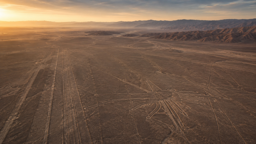
From the ground, many of the lines look almost plain: a pale path across reddish stone, a scraped track fading into the horizon, a shape that refuses to fully reveal itself. But from the air, the desert changes. A hummingbird appears. A monkey curls its tail. A spider stretches across the pampa. Long straight lines cross the land as if someone once pulled cords across the earth and then followed them with a devotion that outlived the makers.
That is the strange power of the Nazca Lines. They are not hidden underground. They are not locked in a ruined temple. They are exposed in open daylight, spread across one of the driest landscapes on Earth, yet they remain among the most persistent ancient mysteries.
The accepted archaeological view sees them as a ceremonial and symbolic landscape created by the people of the region over many centuries. That view is important. It is also not the end of the question. The scale, placement, precision, and endurance of the lines still leave room for wonder. Why this desert? Why these figures? Why such vast forms in a place where survival depended so heavily on water, ritual, movement, and the sky?
Like Göbekli Tepe, the Nazca Lines remind us that ancient people were capable of organizing labor around ideas larger than ordinary survival. Like Stonehenge, they sit at the meeting point of land, sky, ceremony, and uncertainty.
Key Facts
The Nazca Lines are not a single drawing. They are a landscape of geoglyphs, lines, and cleared surfaces spread across the desert plains associated with Nasca and Palpa. UNESCO describes the protected site as covering more than 75,000 hectares, with thousands of large-scale figures, sweeps, and lines created over a long period of ancient activity.
The figures include animals, birds, insects, plant forms, geometric designs, and very long straight lines. Some are recognizable even to modern viewers: the hummingbird, the monkey, the spider, the whale, the dog, the condor, and other forms. Others are less clear, and some may have meanings that do not translate easily into modern categories.
The method was simple in principle but powerful in result. The desert surface is covered with darker, oxidized stones. By removing those stones, ancient workers exposed lighter ground beneath. In a landscape with very little rainfall, the marks could survive for centuries. That same dryness helped preserve the lines, though modern roads, vehicles, erosion, and human activity have created real conservation concerns.
The lines became widely known to modern scholarship in the twentieth century. Peruvian archaeologist Toribio Mejía Xesspe observed the lines from nearby hills in the 1920s. Paul Kosok later studied them from the air, and Maria Reiche devoted much of her life to measuring, mapping, publicizing, and protecting them.
Recent research has made the mystery larger rather than smaller. Drone surveys and artificial intelligence have helped identify hundreds of additional geoglyphs, including smaller figures that earlier aerial surveys missed. This suggests the famous giant forms may be only the most visible part of a much denser symbolic landscape.
What the Evidence Supports
Current archaeology supports the view that the Nazca Lines were made by ancient people of the region using practical ground-clearing methods, not impossible technology. The designs could be laid out with cords, stakes, sighting lines, and careful labor. Their survival is explained by the desert environment, where low rainfall and stable surfaces preserved the exposed lighter soil.
The harder question is not how the lines were made. It is what they were doing there.
Several evidence-based interpretations appear again and again in serious study. One view connects the lines to ritual movement. Some straight lines and cleared “tracks” may have served as paths walked during ceremonies. This fits the idea of the desert as a ritual landscape rather than a static picture gallery.
Another view connects the lines to water. The Nazca region is dry, and ancient life depended on managing scarce water resources. Some researchers have suggested that the geoglyphs, paths, and ceremonial places may have been tied to prayers, offerings, fertility, mountain worship, or sacred geography linked to rain and flowing water.
A third view considers astronomical alignments. Maria Reiche and others explored whether certain lines pointed toward solar, lunar, or stellar events. The available evidence does not turn the entire Nazca system into a single clean calendar, but it does leave open the possibility that some lines were arranged with sky events in mind.
The strongest current interpretation may be that the Nazca Lines had more than one function. A landscape used for centuries can hold many layers: ritual, movement, water, astronomy, social identity, and memory.
Alternative Theories and Speculative Views
The Nazca Lines have always attracted alternative interpretations because they seem to invite impossible questions. Their great animal forms are easiest to appreciate from above. Their straight lines cross the desert with a confidence that feels deliberate and almost architectural. Their scale can make the modern viewer feel as if the ancient makers were speaking to something beyond ordinary ground-level life.
One well-known alternative theory suggests that the lines were meant as signals or landing markers for visitors from the sky. Current archaeology has not verified that interpretation, and the known method of making the lines does not require advanced machinery. Still, the idea persists because the aerial view is genuinely striking. The lines do feel, at first glance, as though they were meant to be seen from above.
A more grounded but still open-ended possibility is that “above” did not mean machines, but gods, spirits, ancestors, mountains, or celestial forces. If the makers believed the sky was inhabited by powers that influenced rain, crops, fertility, and social order, then large figures visible from elevated viewpoints or imagined from above could have had deep ritual meaning.
Some independent researchers have proposed stronger connections to water management, hidden aquifers, or ancient hydraulic knowledge. The evidence remains incomplete, but the water question deserves respect because the region’s dryness was not a side detail. It was central to life. Any long-lasting ritual system in Nazca likely had some relationship to water, whether practical, symbolic, ceremonial, or all three.
Other speculative views focus on geometry and lost knowledge. The straight lines, long sight corridors, and repeated forms can suggest planning systems that are not fully understood. Current archaeology can explain how the lines could be made, but it does not recover the full mental world of the makers. The people who created the Nazca landscape may have used geometry, walking, memory, ritual, and sky observation in ways that do not fit neatly into modern categories.
The careful position is this: the most dramatic alternative claims remain unproven, but the deeper mystery is real. Ancient people clearly turned the desert into a symbolic field on a scale that still exceeds simple explanation.
Why It Matters
The Nazca Lines matter because they force us to take ancient imagination seriously.
It is easy to reduce ancient civilizations to tools, pottery, and ruins. Nazca asks for something wider. Here was a society willing to remake a desert plain into a surface of memory and meaning. The work was not hidden. It was not casual. It was repeated across generations.
That kind of effort tells us that the landscape itself mattered. The desert was not empty space. It was a sacred surface, a route system, a ceremonial field, a map of relationships between people and powers that may no longer have names we can recover.
The Nazca Lines also matter because they are still changing under our eyes. New discoveries show that the known record is not complete. AI and drone surveys have added hundreds of figures, making it clear that the old mystery was only partly mapped.
That makes Nazca part of a wider pattern. The more carefully we look at ancient places, the more complicated they become. The Antikythera Mechanism changed assumptions about ancient mechanical knowledge. The Great Pyramid of Giza still raises questions about planning, labor, and sacred architecture. Nazca does the same with landscape.
Open Questions
- Were the largest Nazca figures meant primarily for divine, ceremonial, or elevated human viewing?
- Did different classes of lines have different purposes: processional, astronomical, social, or water-related?
- How many geoglyphs remain undiscovered beneath faint desert surfaces?
- Were the smaller relief-type figures meant for walkers along ancient paths?
- How directly were the lines connected to Cahuachi, water rituals, mountains, fertility, or pilgrimage?
- Did the makers understand the complete figures mentally from ground level, or were they relying on surveying methods and inherited design traditions?
Sources and Source Notes
- UNESCO World Heritage Centre, “Lines and Geoglyphs of Nasca and Palpa,” for official description, date range, protected area, cultural criteria, and preservation context.
- UNESCO Outstanding Universal Value statement for details on the ritual and symbolic character of the landscape, the chronology of Paracas and Nasca phases, and the categories of representational and geometric geoglyphs.
- Maria Reiche research history and public preservation legacy, including her mapping and archaeoastronomical interpretations.
- Masato Sakai, Akihisa Sakurai, Siyuan Lu, Jorge Olano, and Conrad M. Albrecht, “AI-accelerated Nazca survey nearly doubles the number of known figurative geoglyphs and sheds light on their purpose,” Proceedings of the National Academy of Sciences, 2024.
- The Guardian report on the 2024 AI-assisted discovery of 303 previously unknown geoglyphs near Nazca.
- Anthony F. Aveni, Between the Lines: The Mystery of the Giant Ground Drawings of Ancient Nasca, Peru, for broader scholarly discussion of astronomy, ritual, and landscape interpretations.